 |
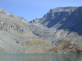
Doesen/Dösen
rock
glacier (46°59'12" N, 13°17'08" E) is located in the
Ankogel group of the |
References (selected):
Schmöller, R. and Fruhwirth, R. (1996):
Komplexgeographische
Untersuchungen auf dem Dösener Blockgletscher (Hohe
Tauern, Österreich). In: Beiträge zur
Permafrostforschung in Österreich. Arbeiten aus dem Institut
für Geographie der Karl-Franzens-Universität Graz, 33, pp.
165-190. [ PDF
]
Lieb, G.K. (1998): High-mountain permafrost
in the Austrian Alps. In: Proceedings of
the 7th International Conference on Permafrost, Yellowknife,
Canada, pp. 663-668. [ Paper ]
Nutz, M. (2005): Lehr-, Lern- und
Erlebnispfade zur Umweltbildung. Krämer Verlag,
Keller-Pirklbauer, A., Lieb, G.K.,
Kaufmann, V. (2022): Rock
Glaciers in the Austrian Alps: A General Overview with
a Special Focus on Dösen Rock Glacier, Hohe Tauern
Range. In: Embleton-Hamann, C. (ed.),
Landscapes and Landforms of Austria, World
Geomorphological Landscapes, Springer, Cham, Part
II(27), 393-406. [
https://doi.org/10.1007/978-3-030-92815-5_27 ]
For more information on the Dösen rock glacier kinematics,
please see http://www.staff.tugraz.at/viktor.kaufmann/Doesen_Rock_Glacier/
Animation of the Dösen rock
glacier movement, please see https://www.staff.tugraz.at/viktor.kaufmann/animations.html#Doesen_rock_glacier
ORF ON: ORF III Land der Berge: Sehnsuchtsort: Berge, 2021,
44 Min. (Ausschnitt: 12 Min.)
![ORF ON 2021 Land der Berge: Sehnsuchtsort: Berge
[ Arthur-v.-Schmid-Haus, Dösener See, Dösener
Blockgletscher ] ORF ON 2021 Land der Berge:
Sehnsuchtsort: Berge [ Arthur-v.-Schmid-Haus, Dösener
See, Dösener Blockgletscher ]](2021_Land_der_Berge_Sehnsuchtsort_Berge_Flugaufnahme_Doesener_Tal_ORF_III_ORF_ON_screenshot.jpg) |
Dokumentation
(Produzentin: Andrea Eidenhammer, Redaktion: Manuela
Strihavka);
Protagonisten: Pia und Bernd Fuchsloch, Andreas and Leo
Kellerer-Pirklbauer, u.a.
 |
 |
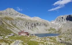
Photo, f.l.t.r.: Säuleck (3086 m), Arthur-v.-Schmid-Haus
(2275 m), Seewände with Dösen Lake (2270 m), Mallnitzer
Scharte (2673 m) with Dösen rock glacier,
taken on August 17, 2021, (c) Viktor Kaumann.
last update: december 20, 2025